
See Earth’s Forests as Never Before in Biomass Satellite’s First Images
New images from the European Space Agency’s Biomass mission show how the satellite uses advanced radar to map flows of carbon through our planet’s most precious and remote ecosystems
An artist’s concept shows how the European Space Agency’s Biomass satellite in low-Earth orbit can use advanced radar to see through thick jungle canopy to measure otherwise-hidden activity on the surface below.
Just two months after its launch, the European Space Agency (ESA) Biomass satellite is already showing us Earth in a whole new light.
On June 23 the ESA released the mission’s first images, which showcase its unique capability to peer through dense vegetation to study our planet’s forests and other ecosystems as never before. Using cutting-edge radar technologies, the satellite is on a five-year mission to survey forests across sprawling swaths of the globe, looking beneath their canopies to accurately assess their total woody biomass—trunks, limbs, stems, and so on. By measuring all that material and how it’s changing over time, scientists can better monitor deforestation trends and track the flow of carbon through ecosystems to enhance our understanding of Earth’s rapidly changing climate. The satellite is still in its six-month-long commissioning phase, but now we have a taste of what is to come.

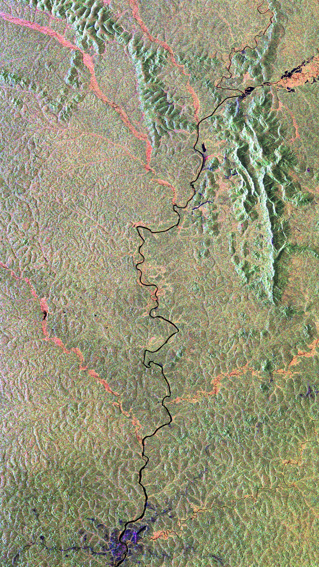
This image features a section of the Bolivian rainforest. Each color represents a distinct ecological feature sensed by the radar, including forests, bodies of water, wetlands, and grasslands.
On supporting science journalism
If you’re enjoying this article, consider supporting our award-winning journalism by subscribing. By purchasing a subscription you are helping to ensure the future of impactful stories about the discoveries and ideas shaping our world today.
The image shown above displays a section of the Amazon rainforest in Bolivia with the Beni River meandering through. Each color represents a different ecosystem feature: black for rivers and lakes, pink for wetlands and floodplains, green for rainforests, and purple for grasslands. The World Resources Institute’s Global Forest Review ranks Bolivia among the top 10 countries with the most tree cover loss between 2001 and 2024. During this time, Bolivia lost the equivalent of 15 percent of the total forest cover it had in 2000, in large part to encroaching agricultural plots and cattle ranches. These images and their associated data can help researchers keep careful tabs on deforestation and its impacts on local and global ecosystems.
The image below highlights the satellite’s power by comparing its observations with those gathered by a Biomass predecessor, ESA’s Copernicus Sentinel-2 mission, in the same location. The new pictures represent a significant increase in detail that is primarily owed to Biomass’s main instrument: the P-band synthetic aperture radar. P-band radio waves are longer than others more typically used in such radar systems, allowing them to pass through layers of foliage, soil and other materials to create accurate three-dimensional maps of otherwise hidden landscape features.

This image from the Biomass satellite (bottom) contains a significant amount of detail not represented in the Copernicus Sentinel-2’s image of the same location (top).
Because of engineering challenges as well as diplomatic ones, this is the first time P-band radar has been used in orbital Earth observations—the P-band radio frequency is typically reserved for American and European missile-detection systems. (In order to ensure it will not interfere with the U.S. Department of Defense’s space-object-tracking radar systems, Biomass will not observe North and Central America, Europe, and some Arctic regions.)
The next three images below demonstrate just how deep the P-band radar can go. They display topographic features of rainforests in Indonesia, the Sahara Desert in Chad and the Transantarctic Mountains adjacent to the Nimrod Glacier in Antarctica, respectively.

A Biomass image showing a segment of the volcanic Halmahera rainforest in Indonesia.
Pictured above is Indonesia’s mountainous Halmahera rainforest, featuring rugged topography shaped by outpourings from the numerous volcanoes that pockmark the region. One of them, the active volcano Mount Gamalama, can be seen off the coast on the far left.

The Biomass satellite’s radar can reach as deep as five meters into dry sand, demonstrated in this image showing the Tibesti mountain range located in the Sahara desert in the extreme north of Chad.
Though the main goal of the Biomass satellite is to catalog forests, it will also study other environments.
Above is a portion of the Tibesti Mountains situated in the central Sahara Desert in northern Chad. Able to map features as far as five meters beneath dry sand, the satellite can reveal ancient geologic details, such as dried-up riverbeds and lakes, now buried below the Sahara’s ever-shifting dunes. These data can help researchers understand past ecological changes in such regions—and could even help unearth hidden pockets of precious groundwater in arid, remote deserts.
Biomass can also penetrate into ice, pictured below, and collect information about ice-sheet structure and movement that could be used to better understand what controls the slide of glaciers into the sea.

ESA Biomass satellite image of a portion of the Antarctic Transantarctic Mountains with the Nimrod Glacier flowing into Ross Ice Shelf.
Below, another image features jungle-covered terrain in Gabon and prominently displays the Ivindo River, which nurtures the surrounding rainforest. The predominantly green color of the image indicates dense vegetal growth—a sign of a healthy rainforest.
Biomass captured this image over Gabon in Africa. Surrounding the Ivindo River and its tributaries, the image is predominantly green, representing dense forest.
The final image shown here, below, is the very first one the satellite produced. It displays a portion of the Amazon rainforest in Brazil, highlighting the topography of the region alongside features such as rivers, wetlands and grasslands.

Biomass satellite image of the Amazon rainforest in northern Brazil. This is the very first image that Biomass returned. The dark green patch on the top right represents a densely forested area.
Only a small portion of the vast Amazon has been studied in-depth and on the ground. This is largely because of its scale and the associated difficulty of reaching some of its most remote regions. Innovative satellites like Biomass could greatly increase our knowledge of these overlooked places and similar ones around the world, helping researchers better understand—and protect—our changing planet and its myriad beautiful ecosystems.