Millions Swelter Under Relentless Heat Dome Smothering Eastern U.S.
High humidity and low overnight temperatures will put tens of millions of people under heat alerts over the course of the coming week
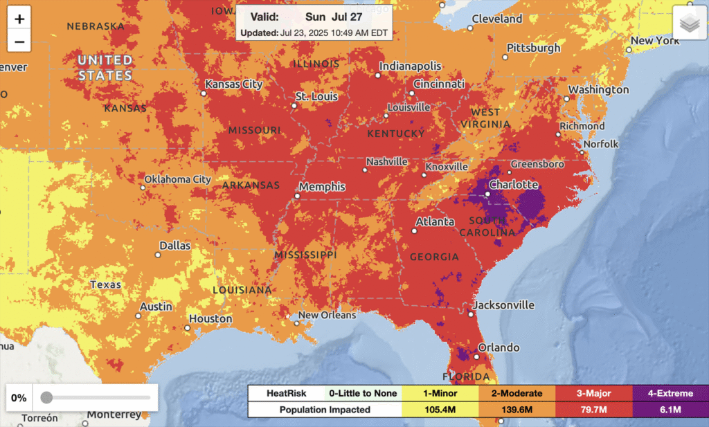
HeatRisk forecast for July 27, 2025. The NWS HeatRisk is an experimental color-numeric-based index that provides a forecast risk of heat-related impacts to occur over a 24-hour period.
National Weather Service/NOAA
Tens of millions of people will swelter under a lingering heat dome swirling over the eastern half of the U.S. in the coming week, meteorologists warn.
On July 23 more than 35 million people are at a major or extreme risk of heat effects, according to the National Weather Service, a branch of the National Oceanic and Atmospheric Administration. That at-risk population is presently centered along the Mississippi River Valley. Current forecasts show the number doubling on July 24 as hot weather shifts eastward. By July 25, it will reach nearly 90 million, with advisories or warnings covering most of the eastern half of the country.
“Even though it’s midsummer, this is pretty notable,” says Bryan Jackson, a meteorologist at the NWS Weather Prediction Center in College Park, Md.
On supporting science journalism
If you’re enjoying this article, consider supporting our award-winning journalism by subscribing. By purchasing a subscription you are helping to ensure the future of impactful stories about the discoveries and ideas shaping our world today.
READ MORE: Heat Is More Than Just Temperature—Here’s How We Measure It
The miserable conditions are the result of what meteorologists call a heat dome, a weather pattern that occurs when a high-pressure mass of air traps heat in place. The phenomenon is often caused by the behavior of a high-altitude river of wind called the jet stream.
For people under the sweltering influence of a heat dome, the weather pattern can be excruciatingly tedious to endure. “Heat domes are generally slow to form and slow to dissipate,” Jackson says.
The current event fits that pattern, with heat conditions expected to continue for a full week at least. Simply glancing at a thermometer may not show how unpleasant conditions are, however; this heat wave is being particularly influenced by high humidity that is keeping overnight temperatures relatively warm, offering people little respite.
“With it being midsummer, it’s not standing out that much in terms of temperature,” Jackson says. “But with the high moisture we are seeing, there will actually be quite a few record-high minimum temperatures.”
The heat dome is currently centered over Memphis, Tenn., Jackson says, and the Southeast will see grueling temperatures throughout the week. But the full geographic scope of the heat dome will move as the hot air rotates in place. Today the Midwest is sweltering, as it has been for several days, worsened somewhat by an unpleasant phenomenon dubbed “corn sweat.”
The Ohio River Valley will face the worst conditions on July 24, and the Eastern Seaboard will do so on July 25. Meanwhile the southeastern U.S. is forecast to see the highest heat risk over the weekend and into next week. The mid-Atlantic, the Carolinas and the Southeast are posed to potentially break records for the highest overnight lows during this period, Jackson notes.
Long periods of summer heat are becoming more common as climate change continues to unfold. A recent analysis shows that many cities across the eastern half of the U.S. are experiencing increasing numbers of “heat streaks”—periods of three or more consecutive days with maximum temperatures among the top 10 percent of local daily highs from 1991 to 2020.
If you live in an affected area, check out our science-backed tips for staying healthy in extreme heat and for keeping your house cool.


